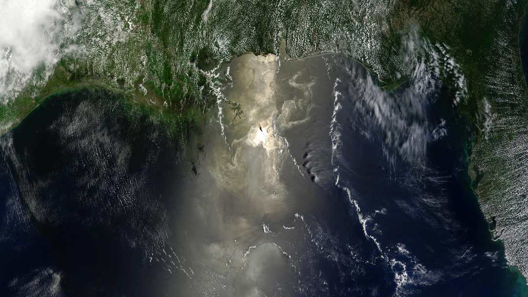
Update: this post began our coverage of the UAE slick; it was followed by updates on 26 and 31 October 2026.
On Friday, 23 October 2026, the UAE said containment operations were under way for oil leaking from a tanker off its coast. All beaches and coastal areas around Umm Al Quwain were temporarily closed, and fishermen and sea users were urged to avoid the area. In neighbouring Sharjah, Al Hamriyah Beach was closed as a precaution, according to Reuters.
The UAE authorities have not named the tanker or said what caused the spill. Analysts have: Martin Kelly, CEO of Orbital Risk Intelligence, told Reuters the oil was coming from the tanker Gem No.2. Shipping sources said the vessel was struck by an unidentified projectile 13 nautical miles west of Al Jazeera on 9 October, causing a fire that was later extinguished. Satellite imagery from 19 and 21 October appears to show the slick coming from the ship, covering approximately 160 square kilometres, according to Leon Moreland of the Conflict and Environment Observatory.
Reuters' reporting places the spill in a wider context: since the start of the US-Israeli war with Iran, attacks on commercial vessels in Gulf shipping lanes have raised security risks — earlier the same week, another tanker was struck off Qatar's coast. The conflict's environmental fallout is real: in August, oil from a tanker aground off Oman began reaching the mainland coast.
Moreland's warning is the one that matters: the slick sits close to shore, raising the chance it impacts beaches and sensitive habitats. Maritime intelligence firm Windward first identified the spill on 20 October — a VLCC-sized vessel leaking about 25 kilometres off Umm Al Quwain — and said currents could carry it toward the coast. Its drift model showed the oil reaching Sharjah's and Ajman's desalination intakes and ports by 22–23 October if the leak was not stopped. That detail explains the urgency: the UAE relies on desalination for most of its drinking water, and its ports, industry and fisheries share the same coastline. Residents in Sharjah, Ajman and Umm Al Quwain reported strange odours on social media; the ministry said they posed no health risks.
Most people have never seen what an oil slick actually is. It is not a solid black lake — it is a thin film, sometimes only micrometres thick, that spreads, drifts with wind and current, breaks into patches and reforms. The 160-square-kilometre figure is an area estimated from satellite imagery, not a pool of crude, and oil can be nearly invisible from a ship's deck in poor light. That is why satellites have quietly become the sea's first responders: they see the slick from hundreds of kilometres up — in daylight, and with radar satellites at night and through cloud — long before a patrol boat reaches the scene.
Those eyes are getting sharper. In August, scientists at Plymouth Marine Laboratory reported the largest ever global assessment of satellite data used to monitor ocean health: more than 13,000 satellite observations matched against measurements taken at sea, with a mean error of just 30% — inside the space agencies' 35% target. ‘Quality assured satellite ocean colour data is a vital tool for scientists to assess the state and health of our global ocean,’ said joint lead author Dr Gavin Tilstone. The study is about ocean colour and plankton, not oil — but it is the same public infrastructure that tracks slicks: decades-long records from Sentinel satellites, checked against measurements from ships.
At ground level, far from Umm Al Quwain, a closed beach is a lost week of income for a fisherman — on the Mekran coast, in Karachi's harbour, or in the Gulf. For a small coastal business the lesson is practical: know where your water, your catch and your customers' trust come from, and have a number to call before the smell arrives. For students and teachers, the spill is a ready-made classroom: physics, geography, chemistry and civics in one story — and the satellites that tracked it publish their imagery openly, free for any student to explore.
Where does AstolixGen fit into this, honestly? AstolixGen follows marine and climate technology closely, and the truth is humbling: almost everything that matters is already free and public — the satellite data, the drift models, the research. What is missing in most coastal places is the last mile: an office that gets the alert on time, a dashboard a non-expert can read, a routine that turns a satellite image into a local decision. That plumbing — connecting open data to the people who need it — is the kind of automation work we build, and the kind of IoT monitoring we are designing in our pilot concepts. We are not the responders in this story. The tools exist for far more coastlines to watch themselves; the gap is organisation, not technology.
The honest caveat belongs at the end. A satellite can show you a slick, but it cannot name the ship, assign blame or order a cleanup. Here the vessel's identity came from analysts and shipping sources, not from orbit, and the UAE authorities have named no tanker and no cause. And this spill sits inside a conflict — ships are being struck, and strikes and sabotage produce some of the hardest spills to respond to, because the danger does not end when the leak starts. Remote monitoring is one layer of the response, not the whole response. It sees the oil. The decisions — who closes the beach, who compensates the fisherman, who stops the next strike — are still made by people.