Marine Pollution · Awareness
The film on the sea: understanding oil slicks.
You have seen it on a cup of tea — a thin, shiny film of oil floating on top, refusing to mix. An oil slick is the same thing at the scale of an ocean. This page explains, in plain language and real photographs, what slicks are, where they come from, and why they matter to everyone who lives by the sea.
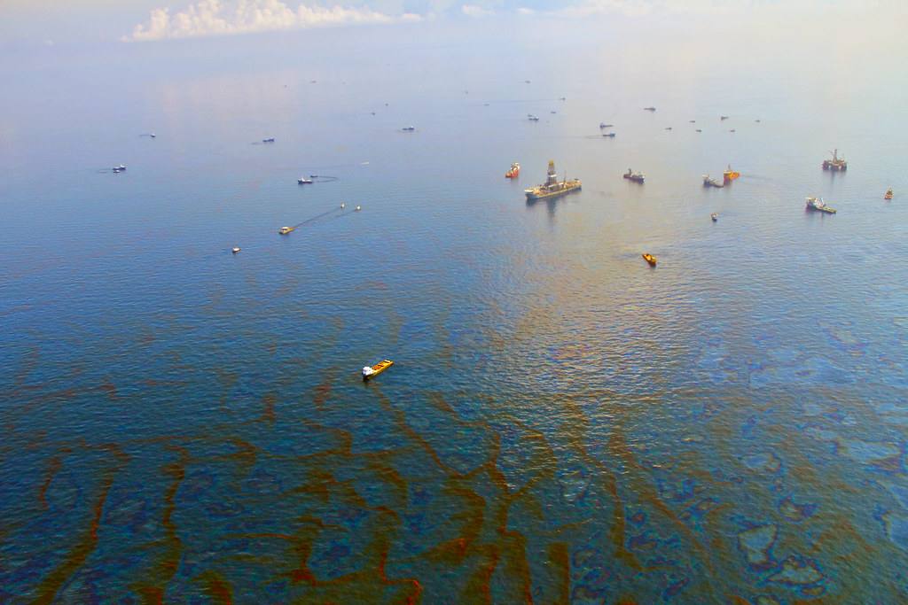
A major slick seen from the air: response ships work among streaks of oil that stretch to the horizon. A slick this size can begin from a single damaged tanker. Photo: Wikimedia Commons (CC BY-SA 4.0).
What is an oil slick?
Oil and water do not mix. Spilled oil floats, and it does not stay in a blob — it spreads out into a layer thinner than a sheet of paper, which is why even a small spill can cover a very large area of sea.
The first sign is often a rainbow sheen — shifting colours on the surface, like the photograph beside this text. As the oil thickens and weathers it turns dark brown or black, breaks into patches and tar balls, and drifts with wind and current until it reaches a shore.
Because the film sits on the surface and calms the tiny waves, a slick also looks different from space: satellites carrying radar can spot the unnaturally smooth patch day and night, through cloud. That is how large slicks are usually first noticed.
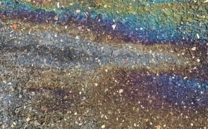
The rainbow sheen of a thin oil film — the sign to look for. If you see colours like this on harbour or beach water, oil is present. Photo: Pexels.
Causes
Where does the oil come from?
Big accidents make the news, but most oil in the sea arrives in smaller amounts, again and again.
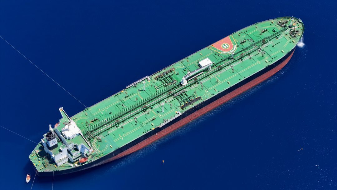
Most of the world's oil travels by sea in tankers like this one — which is why shipping routes are where slicks most often begin. Photo: Pexels.
- Tanker and ship accidents — groundings and collisions that tear open fuel or cargo tanks.
- Offshore platforms and pipelines — leaks and blowouts during drilling and transfer.
- Routine shipping — oily bilge water and tank washings released at sea, much of it illegal, adding up drop by drop.
- Ports, terminals and ship-breaking — spills during loading, and oil and sludge washed off beaches where old ships are dismantled.
- The land itself — used engine oil and factory waste poured into drains and rivers, carried down to the coast.
Why it harms
Birds are usually the first victims. Oil destroys the waterproofing of their feathers; they lose insulation, cannot fly or feed, and poison themselves trying to clean their feathers.
Fish and shellfish absorb oil compounds that are toxic and can make seafood unsafe. Mangrove forests — the nurseries of the coast — suffocate when oil coats their breathing roots, and a damaged mangrove can take decades to return.
People pay too: fishing families lose their catch and their income, beaches close, and cleaning a shoreline costs far more than preventing the spill. Oil in the sea does not disappear quickly — heavy residues can persist in mud and sand for many years.
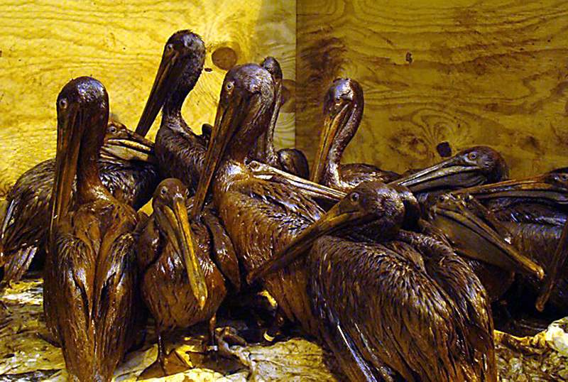
Pelicans coated in oil after a major spill, waiting for rescue teams to wash them. Many oiled birds do not survive. Photo: International Bird Rescue Research Center, via Wikimedia Commons (CC BY 2.0).
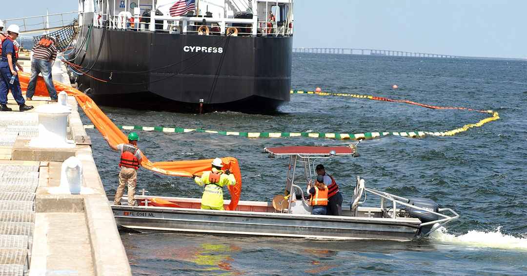
Crews lay a floating containment boom — an orange barrier that corrals the oil so it can be collected. Photo: U.S. Navy / Patrick Nichols, via Wikimedia Commons (public domain).
How spills are fought
Speed decides everything. Responders surround the oil with floating booms, scoop it up with skimmer vessels, protect the most sensitive shores first, and wash and treat oiled wildlife.
Aircraft and satellites search from above, because a slick moves and spreads every hour. But even the best response recovers only part of the oil — which is why watching the sea, and catching a slick in its first hours, matters so much.
Karachi has lived this lesson. In 2003 the tanker Tasman Spirit grounded off Clifton and released thousands of tonnes of crude onto the city's beaches — a cleanup that took months and a shoreline that carried the marks for years.
Footprints
Where the sea already carries oil
Four coasts, mapped from satellite radar. Every orange patch is a potential slick detection recorded by SkyTruth's Cerulean system, built on Sentinel-1 radar — a place where the sea's surface looked unnaturally smooth, the signature oil leaves behind. A detection is not proof of a spill; it is a footprint that deserves a human look.
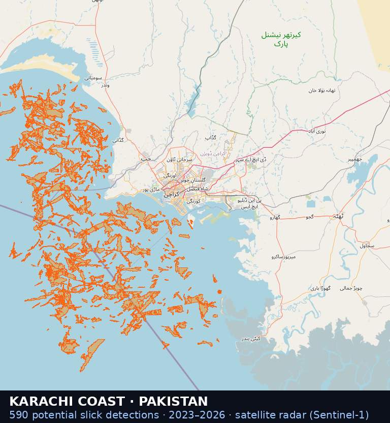
Karachi coast, Pakistan — 590 potential slick detections, 2023–2026. Our home coast: the harbour approaches, the Clifton–Korangi shore and the Gadani ship-breaking coast, watched from space.
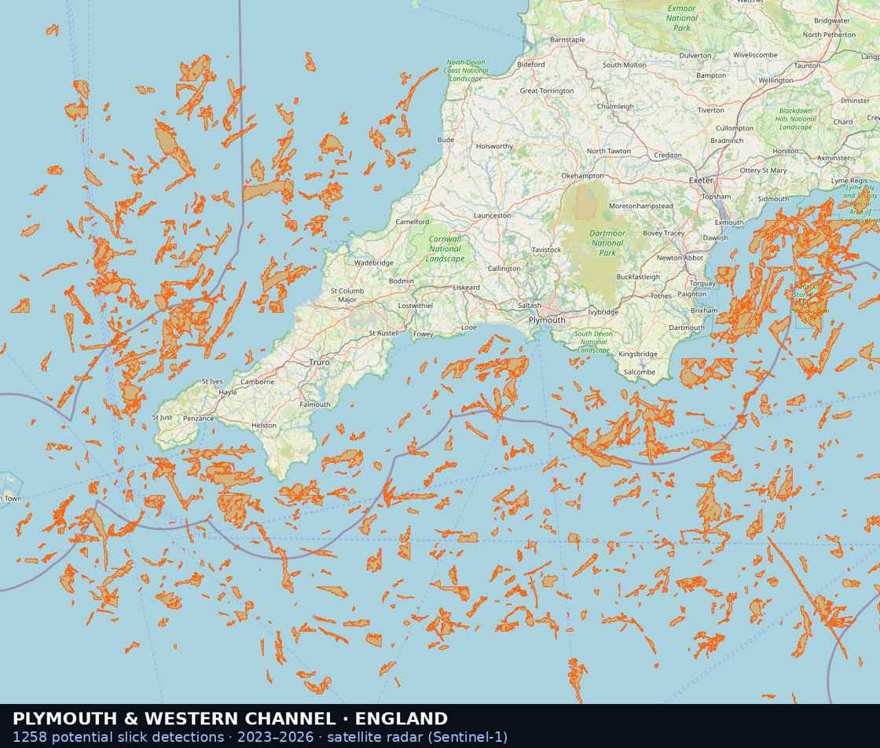
Plymouth & the Western Channel, England — 1,258 potential slick detections, 2023–2026. One of the busiest shipping lanes in the world, at the door of Britain's marine science community.
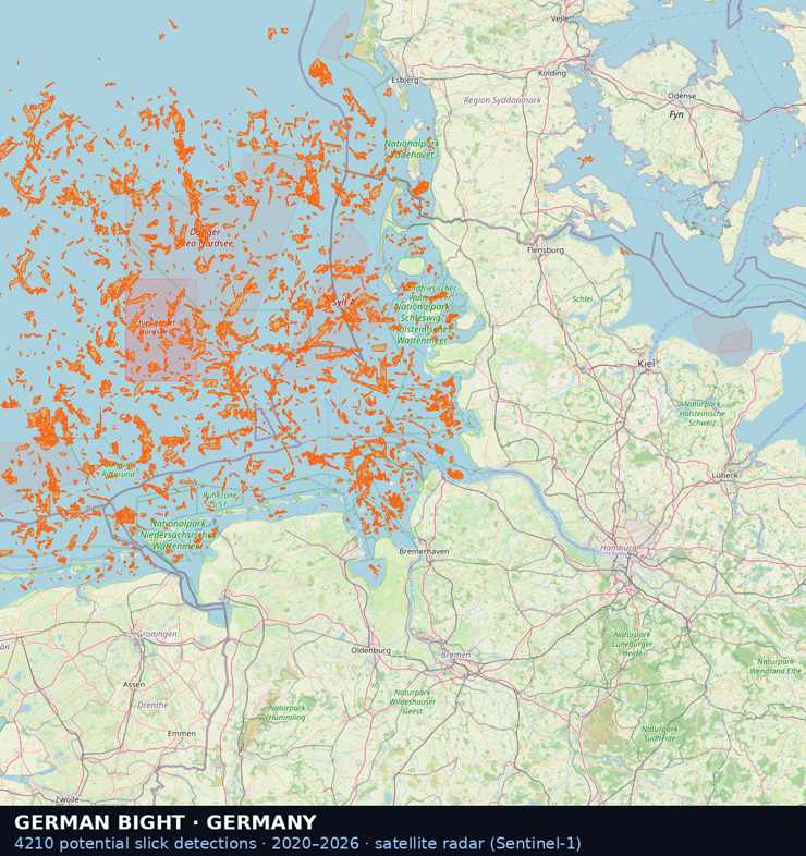
German Bight, Germany — 4,210 potential slick detections, 2020–2026. Germany's North Sea coast, where the great Elbe and Weser shipping lanes meet the Wadden Sea shallows.
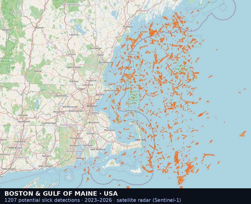
Boston & the Gulf of Maine, USA — 1,207 potential slick detections, 2023–2026. A working fishing coast where a single spill reaches lobster grounds, whale habitat and harbour towns at once.
The startup behind this page
AstolixGen is a young technology startup based in Karachi, Pakistan. By day we build AI and automation systems for businesses; from our own coast, we are also building a marine-pollution monitoring effort that watches named stretches of sea — the four coasts mapped above among them — for the footprints oil leaves on water.
The work is beginning to draw scientific interest. A senior scientist at Plymouth Marine Laboratory — the United Kingdom's marine research institute — replied to our enquiry calling the monitoring work “ambitious and exciting”, and asked for a demonstration and technical documentation. We count that as encouragement, not endorsement: the science still has to earn its place, in the open and under expert eyes.
Your part
What you can do
You do not need a ship or a satellite to protect a coast. Four small things genuinely help.
Never pour oil into drains
Used engine oil tipped into a drain or onto open ground finds its way to the sea. Hand it to a workshop or collection point instead.
Learn the rainbow sign
A rainbow film, a fuel smell on the water, or black patches on the sand all mean oil. Noticing is the first step of every response.
Report what you see
Tell the Pakistan Maritime Security Agency, your port authority or the Sindh Environmental Protection Agency — with the place and time. An early report buys the response its most valuable hours.
Stand with the coast
Join beach cleanups, support the fishing and turtle communities who sound the alarm first, and share this page — awareness is a form of protection.
An awareness page from AstolixGen. Photographs: aerial slick — Wikimedia Commons, CC BY-SA 4.0; oil sheen and tanker — Pexels; oiled pelicans — International Bird Rescue Research Center via Wikimedia Commons, CC BY 2.0; containment boom — U.S. Navy photo by Patrick Nichols via Wikimedia Commons, public domain. Footprint maps: © OpenStreetMap contributors; detection data from SkyTruth Cerulean, built on Sentinel-1 satellite radar (European Space Agency).